| Bing Map Apps SDK announced at TechEd |
| Tuesday, 08 June 2010 | |||
|
There have been a few interesting announcements at Tech Ed 2010 but the one of most interest to programmers is the news that Bing Maps has been augmented by a new Map App SDK.
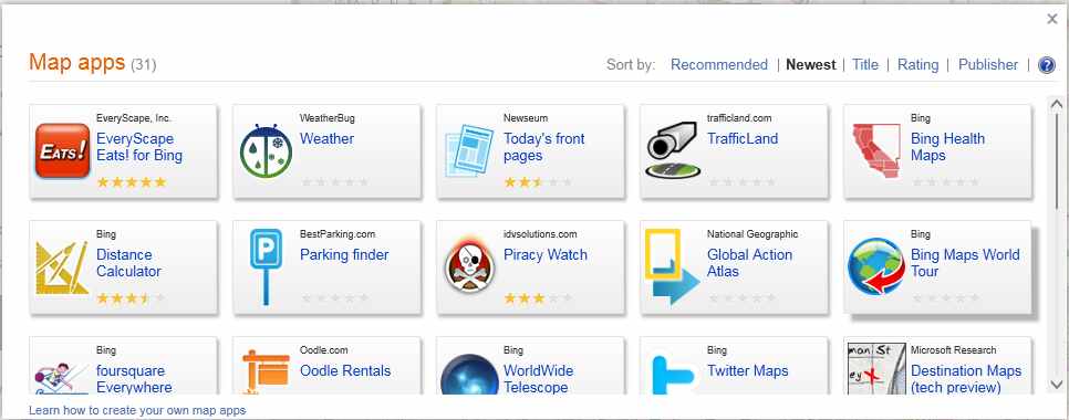
A Bing Map App is a web service that is integrated into the application layer within Bing Maps. What this means in simple terms is that you create an App and Microsoft hosts it for you on its map site. Basically if you have some data, or sets of data, that you could usefully display on the usual Bing Map then an App is what you want to create. If you want to build something that you host in your own website then you need to use the Bing Maps Platform. New in Bing Map Apps is a rating system for Apps. This allows users to voice their opinion of your efforts using a five-star rating system.
You can download the SDK and start creating Bing Map Apps almost at once - all you need is a Live ID. Your App can be tested on the site itself via a sandbox area and when you are happy its all working you can upload it to the Bing Map App Gallery. To help you test your App there is a new Bing Map App Test Tool - simply add ?Developer=1 to the URL to run in debug mode. Apps are reviewed before being published in the gallery so inclusion isn't guaranteed. Have a look at the two new sample Bing Map Apps - Weather Map App and EveryScape Eats.
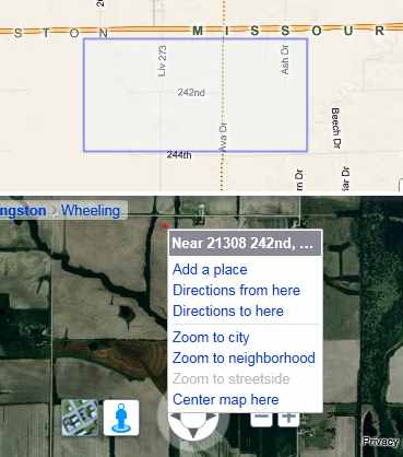
If you think you’ve got a killer app you should go for the title King of Bing Maps. Microsoft is holding a contest for the best Bing Map Apps and the winner will be dubbed the King of Bing Maps. Check out the contest web site for more details: http://www.kingofbingmaps.com/. FaceliftThe Bing Maps system has also had something of an upgrade with the move to Silverlight 4.0. For example you can now create gigapixel 360 degree panoramas using Microsoft Research's Image Composite Editor ICE and publish then to Photosynth. The connection with Bing Maps is that now you can geotag the panoramas and view them using the Photosynth Map App. Map Overlays are a way of integrating with the Bing Map tile server so that you can supply graphics to cover an area that pans and zooms with the map. This means that you can enhance a map with additional mapping information. The Map user interface has been improves with an Action bar - basically a set of buttons along the bottom left. A right-click context menu has also been added courtesy of the new upgrade to Silverlight 4. The context menu is linked to the geographical location where the click occurred.
The new right click menu and breadcrumb feature A new full screen mode also makes it easier to use maps in presentations and a graphical breadcrumb feature lets you see where you are in a wider context when you are zoomed in on something. You can also do a reverse business address lookup, i.e. you supply the address and it returns the name of the company. And finally the original BrandFinder program, whereby companies had their logos associated with places where they could be bought, is re-opened for new business - brands that is.
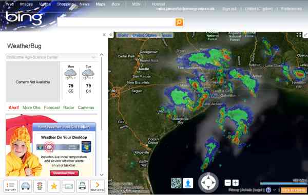
Weatherbug in action API extensionsAlso new is a REST API to add to the Javascript, SOAP and Silverlight approaches to using Bing Maps in your application. The API is split into four sections - Locations, Imagery, Routes and Spatial data. The spatial data API is used for batch geocoding, i.e. converting addresses into geographic locations. The Ajax Javascript control has also been enhanced by being stripped down! There are now two versions - the usual full control which implements everything and a core version which is faster to load if you don't need a full set of features. You can also now use search and geocoding methods and pushpins can be dragged by the user.
Related articles:Getting Started with the Bing Maps Silverlight Control Getting started wth Bing Maps (Virtual Earth)
<ASIN:1593272715> <ASIN:1430216204> <ASIN:1847199763> <ASIN:0470534044> <ASIN:1847199763> <ASIN:0596101619> |
|||
| Last Updated ( Tuesday, 08 June 2010 ) |


