| Neural Networks for Fossil Discovery |
| Written by Lucy Black | |||
| Sunday, 13 November 2011 | |||
|
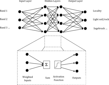
Neural networks have proved their worth at finding patterns in many types of data from spam filtering to speech recognition. Palaeontologists are the latest to put them to work - to identify potentially productive localities from remotely sensed imagery. There is so much satellite imagery that it is a wonder that anyone has to go anywhere to find things any more. Simply look at the satellite pictures until you find what you are looking for. The problem is, of course, that there are a lot of satellite pictures to look at and you might not know what you are searching for actually looks like in a multi-spectral image of the ground. One solution might be to crowd source the search, but that doesn't solve the problem of knowing what you are looking for. A much better idea is to use AI to learn what existing sites look like and then find new sites for you to go out and explore. This is exactly what a team of fossil hunters have done. The research, detailed in the journal Evolutionary Anthropology has produced a model that uses a neural network (ANN) trained to recognize the spectral characteristics of known productive localities and other land cover classes, such as forest, wetlands, and scrubland based on the analysis of remotely sensed (RS) imagery. Using spectral signatures, the model then classifies other pixels throughout the study area. The results of the neural network classification can be examined and further manipulated within a geographic information systems (GIS) software package.
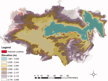
The ANN used is fairly standard. For the analysis, the input layers include Landsat 7 bands 1-5 and 7 from the ETM+ sensor; the outputs include the 10 spectral land-cover classes. The researchers, led by Bob Anemone, a palaeontologist at Western Michigan University have developed and tested this model on fossil mammal localities in deposits of Paleocene and Eocene age in the Great Divide Basin of southwestern Wyoming, but similar analytical approach can be easily applied to fossil-bearing sedimentary deposits of any age in any part of the world. A summary of the research on nature.com explains that the network independently identified several places from which palaeontologists had unearthed mammal fossils, and researchers are now set to use its predictions to explore further sites in 2012. Anemone, who has been scouring the Great Divide Basin for fossils of mammals from the early Eocene epoch, about 50 million years ago is excited by the prospect: "We're going to go to some areas we've never been to, that we wouldn't have been aware of, and see what we find." |
ASP.NET Core 10 Preview Released 31/03/2025 Microsoft has announced the second preview release of .NET 10 with enhancements across the .NET Runtime, SDK, libraries, C#, ASP.NET Core, Blazor, and .NET MAUI. |
Bill Gates Shares The Code That Launched Microsoft 06/04/2025 To celebrate Microsoft's 50th Anniversary, Bill Gates has shared the original Altair BASIC Source Code. However it's not been open-sourced in a GitHub repo - instead it's available as a 157-page [ ... ] |
More News
|


