| Street View on steroids |
| Written by Harry Fairhead | |||
| Tuesday, 26 April 2011 | |||
|
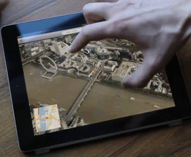
High resolution 3D photorealistic models can be constructed using nothing but standard cameras. Hi-resolution opens up new areas of application.
If you have ever wondered what to do with petabytes of data storage it seems C3 Technologies has a good way of using it up in no time at all. It has an approach to capturing 3-D models of the real world, mainly cities, that provides a resolution of 6 inches (15cm). The images are captured by a plane using a set of professional digital SLR cameras. The images include overlapping views from the side but the exact setup is secret. From here the raw images are processed by AI machine-vision software developed by C3 which uses the stereo information in the overlapping images to infer depth and hence create a 3D model. The usual technique for capturing 3D data in this way is a LIDAR, i.e. a laser scanner. The C3 method is much cheaper and nearly as accurate. The only down side is that some manual cleaning up is required to produce the final perfect model. The data capture is also completely automated the plane just has to fly over the areas to be modelled and the software outputs the photorealistic 3D model. Not content with collecting cityscape data, C3 has plans to extend to pedestrian, waterway and interior locations, and even to using Segways to speed data collection on a human scale . Currently C3 has one big customer in the form of Nokia and its hi-resolution Ovi Maps. With the help of C3 Ovi Maps could finally have something to offer the end user that makes it preferable to Google or Bing Maps. Of course, there is an API for the C3 data and you can use either C3 Web or Mobile SDKs to add 3D mapping into you applications. The API is Javascript, Flash or Java based and C3 host all of the mapping data using Amazon's EC2. Unfortunately there is no downloadable or free-to-use service to enable you to try it out. And don't think that you can use the OVI Maps SDK to try it out as this too is not available for public download. If Nokia intends to make something of its mapping and to replace Bing Maps on Windows Phone it needs to adopt a more open approach to developers.
High resolution 3D maps open up lots of new possibilities for apps that use geolocation to pin the user down to a particular entrance or a parking spot or even interior space. However, for this to be a real step forward, we are going to have to do something about the current GPS system which hasn't the resolution to match.
More interestingly high resolution whole earth models might even change our behavior in ways that are unpredicatable. After all, people have used Google Earth and street view to evaluate a holiday destination so why not take a virtual holiday?
|
|||
| Last Updated ( Tuesday, 26 April 2011 ) |

