| Google Labs initiative to save the forests |
| Sunday, 05 December 2010 | |||
|
The Google Earth Engine was launched last week at the United Nations Climate Change Conference being held in Cancun with the aim of enabling global-scale monitoring and measurements of environmental change.
Developed by Google Labs it will enable scientists to use the Google "cloud" to analyze the vast amount of satellite imagery that is available. The Google blog explains the contribution Google Earth Engine can make: The images of our planet from space contain a wealth of information, ready to be extracted and applied to many societal challenges. Scientific analysis can transform these images from a mere set of pixels into useful information—such as the locations and extent of global forests, detecting how our forests are changing over time, directing resources for disaster response or water resource mapping. One of the first uses of the Google Earth Engine is development of a system to monitor and stop global deforestation and this video gives more details:
Google is donating 10 million CPU-hours over the next two years on on the Google Earth Engine platform, to strengthen the capacity of developing world nations to track the state of their forests. This is in conjunction with the United Nations REDD Framework (Reducing Emissions for Deforestation and Forest Degradation in Developing Countries) which is a key agenda item at the Cancun Conference.
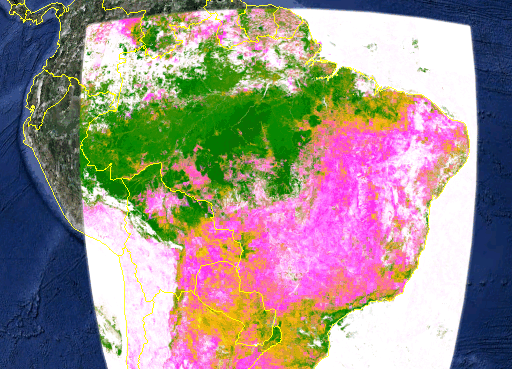
NDFI over the Amazon - the Normalized Difference Fraction index allows deforestation and forest degradation to be visualized
There is an API that enables the development of new ways of using the data but at the moment it is only available to a limited number of partners. As the Earth Engine platform develops Google hopes more scientists will use the API to integrate applications for deforestation, disease mitigation, disaster response, water resource mapping and other beneficial uses. For more infomation visit the Google Earth Engine website.
|
|||
| Last Updated ( Sunday, 05 December 2010 ) |


